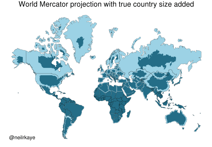
Yet another reason to tut at the Mercator map projectionhttps://brilliantmaps.com/mercator-vs-true-size/
-
@infobeautiful I think all projections distort size and shape, so I'm not sure "true country size" is meaningful here.
Sure, projecting a quasi-spheroid onto a plane will always cause distortions, but you can choose what to distort. Mercator keeps compass bearings and distorts shapes. The Albers Equal-Area projection, among others, keeps sizes but distorts shapes much more. Anyway, you can always calculate the surface area of land. In fact many countries in the world have been quite thoroughly surveyed.
-
@lokjo @infobeautiful it's not an issue about north vs south.
The difference in size comes from the distance to the equator.Ah yes, I thought the equator was the height of northern africa but it's in middle africa.
-
Ah yes, I thought the equator was the height of northern africa but it's in middle africa.
@lokjo @x_tof @infobeautiful also, the southern hemisphere looks a lot more impressive in Mercator if you don't hide the Antarctic!
-
Yet another reason to tut at the Mercator map projection
https://brilliantmaps.com/mercator-vs-true-size/@infobeautiful there's one thing Mercator is good for: timezones. For all other purposes, there are better projections.
-
Yet another reason to tut at the Mercator map projection
https://brilliantmaps.com/mercator-vs-true-size/@infobeautiful ah sure Greenland is TINY.
Denmark should just hand it over and quit this dog in the manger stuff.
/s
-
Yet another reason to tut at the Mercator map projection
https://brilliantmaps.com/mercator-vs-true-size/Author of this map:
https://www.metoffice.gov.uk/research/people/neil-kaye -
R ActivityRelay shared this topic
-
Yet another reason to tut at the Mercator map projection
https://brilliantmaps.com/mercator-vs-true-size/The USA isn't that big, let's invade it!
-
Ah yes, I thought the equator was the height of northern africa but it's in middle africa.
No wonder human perception is so flawed with such input. I too had a misconception of where the equator fell on Africa. I'm glad the link does put Antarctica in perspective on a subsequent map. GIGO
-
Yet another reason to tut at the Mercator map projection
https://brilliantmaps.com/mercator-vs-true-size/@infobeautiful always interesting to see how different maps tell different stories
-
Yet another reason to tut at the Mercator map projection
https://brilliantmaps.com/mercator-vs-true-size/@infobeautiful equal earth should be official
-
Yet another reason to tut at the Mercator map projection
https://brilliantmaps.com/mercator-vs-true-size/@infobeautiful
Just learned something.On the typical Map, that I had in school, the size of nealry every country was wrong.
Thx for this.
Now I have a new rabit-hole...
-
Yet another reason to tut at the Mercator map projection
https://brilliantmaps.com/mercator-vs-true-size/@infobeautiful MAGAmoron must use Mercator Projection when boasting to underage girls about his dick.
-
@infobeautiful I think all projections distort size and shape, so I'm not sure "true country size" is meaningful here.
Greenland's land area is approximately six times the size of Germany. Greenland has roughly the same size as Saudi Arabia. The USA is rougly 5 times bigger than Saudi Arabia.)
(I have heard this this week and just verified it with wikipedia, I found this comparison helpful) -
@lokjo @x_tof @infobeautiful also, the southern hemisphere looks a lot more impressive in Mercator if you don't hide the Antarctic!
@stevefaeembra @lokjo @x_tof @infobeautiful
This one substitutes the Prime Meridian for the equator. (Hilarity ensues) -
@stevefaeembra @lokjo @x_tof @infobeautiful
This one substitutes the Prime Meridian for the equator. (Hilarity ensues)@Osteopenia_Powers @stevefaeembra @x_tof @infobeautiful
Not sure if this is the link you wanted to post.
-
Yet another reason to tut at the Mercator map projection
https://brilliantmaps.com/mercator-vs-true-size/@infobeautiful there's an excellent episode of Map Men about this (all their videos are excellent)
https://youtu.be/jtBV3GgQLg8 -
Yet another reason to tut at the Mercator map projection
https://brilliantmaps.com/mercator-vs-true-size/They gave some Eastern Canada provinces to the US. Don't comply in advance!
-
@infobeautiful ah sure Greenland is TINY.
Denmark should just hand it over and quit this dog in the manger stuff.
/s
@davey_cakes @infobeautiful or show the orange orangutan this map and he'll have a tantrum then move on to something else?
-
Yet another reason to tut at the Mercator map projection
https://brilliantmaps.com/mercator-vs-true-size/@infobeautiful It’s like stepping out of a cold shower!
-
Yet another reason to tut at the Mercator map projection
https://brilliantmaps.com/mercator-vs-true-size/Fascinating, thanks!
Here's obligatory link to great bit from TV's "The West Wing." Where cartographers compare Mercator versus Peters projections for stunned C.J. and Josh.
The head map guy is played with perfect drollery by the invaluable John Billingsley (Star Trek: Enterprise; The Man from Earth, etc.).
Cartographer: "Nothing's where you think it is."
C.J: "Where is it?"
Cartographer: "I'm glad you asked…"